
First of all, we turned to the archives, as all good history researchers do. For once though, we weren’t looking for those account books that enable us to exactly date the creation of the bath house, or the nurseryman’s bill which details exactly what type of tree was planted in those clusters up on the hill. Instead, we were looking for the most juicy, laugh-inducing, heart-twanging diary entries, letters, paintings or sketches that really described firsthand what visitors were doing or feeling as they explored the garden. We were looking for the titbits that offered a clue as to how they were experiencing the garden. Those details that make our twenty-first century bellies turn with excitement as we feel a real and powerful connection with our counterparts from the past.
Then, of course, we had to get permission to reproduce this material. We imagine that this part of the process will be easier for historic landscape staff, because they will have a stronger argument for using the material. Indeed, in many instances, the archives may be owned by the gardens themselves.
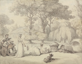
[Thomas Rowlandson, 1756–1827, British, Feeding the Ducklings, undated, Watercolor with pen and brown ink over graphite on medium, slightly textured, cream, wove paper, Yale Center for British Art, Paul Mellon Collection]
Designing the map
Once we had all our material neatly organized and labelled we hired a graphic designer to create a map for our imaginary landscape. We chose to adapt an existing eighteenth-century map, but sites will have either their own historic maps to work with or they can adapt or create a modern version.
This whole process took days rather than weeks, and cost hundreds rather than thousands of pounds. We numbered the features on the map in the historic style, which we hoped would hint at a route that garden visitors could take around the site. For us, this was the trickiest bit, but it would be much easier for real sites, with an existing visitor route. At completion, the graphic designer provided us with low res and high-res jpeg and pdfs of the map, in a size large enough to look great on a full-size computer screen.
Creating the website
Once we had our map we hired a web designer to convert our analogue data and map into a digital entity. Again this all cost hundreds rather than thousands of pounds as we found someone with the right expertise but who wasn’t a top flight, award winning designer with all the associated cost implications. We had a meeting with him early on in the project, in order to check whether he had any technical requirements for the map … he didn’t. At this meeting, the web designer very patiently used words of one syllable to talk us through the technicalities of the project, which turned out to be pretty simple.
This project had been begun with an app in mind, so that visitors could download it and then access the map via their mobile phone whilst actually walking around the garden. However, the web designer tactfully explained that the same advantage could be achieved just as easily using a mobile-friendly website template that will look great on a full-size computer screen but also cunningly convert itself into a version for a tiny phone screen, knowing intuitively how it is being viewed. This means that people based around the globe can virtually walk around the landscape as well as it being visitor friendly at the site itself.
We had been unclear as to how the map would connect through to the archive material, but the designer was great at talking us through how you can create a ‘pop-up’ for each garden feature. These are always present but each one only becomes visible when you click on that feature on the map. We decided that our aim was to whet the historic appetite of people visiting our imaginary garden rather than to support any broader research activities, so there was no need for our material to claim to be a definitive account of any garden feature, or to be in a format readily available to those searching on specific garden terms. Our map is also on its own dedicated website, but would fit ideally into a page on a historic property’s existing website.
Adding audio and film
The main bonus of using digital technology to bring the garden of the past to life is that it allows interpreters to include other forms of media such as music, poetry, paintings and videos of re-enactments.
So at the bowling green digital explorers could hear the following stanza from Joseph Addison’s The Bowling Green being read or watch a video of a re-enactment of the sport in full costume:
Whereas, at the nut grove the sound of harp music could accompany this description from Mrs Delany when the pop up is activated. Similarly, someone accessing the digital experience while in the garden could hear appropriate music at particular spots using digital locating technology:
My garden is at present in the high glow of beauty, my cherries ripening, roses, Jessamine and pinks in full bloom, and the hay partly spread and partly in cocks, complete the rural scene. We have discovered a new breakfasting place under the shade of nut-trees, impenetrable to the sun’s rays, I the midst of a grove of elms, where we shall breakfast this morning; I have ordered cherries, strawberries and nosegays to be laid on our breakfast-table, and have appointed a harper to be here to play to us during the repast, who is to be hid amongst the trees. Mrs Hamilton is to breakfast with us, and is to be cunningly led to this place and surprised.